If you have further insights and thoughts on this article, please contact the author: Zhang Shijie, Investment Department VI, Nanjing Innovation Investment GroupE-mail: zhangsj@njicg.com
Introduction
Satellite remote sensing is a technology that detects and receives electromagnetic wave information radiated and reflected from target objects through sensors (i.e., remote sensing payloads) at high altitudes, thereby identifying the attributes and spatial distribution characteristics of objects, and acquiring satellite data through remote sensing technology platforms for analysis and processing. According to its imaging principle, it can be divided into optical remote sensing and radar remote sensing.
Synthetic Aperture Radar (SAR) satellites belong to the category of radar remote sensing. With their unique advantages of all-time, all-weather operation and strong penetration capability, they have become an indispensable payload platform in the field of remote sensing and driven the global market into a period of rapid growth. SAR satellites are relatively rarer than ordinary remote sensing satellites. Domestically, there is a significant demand gap in fields such as observation of cloudy and rainy areas, acquisition of global high-precision DEM data, and disaster prevention and mitigation applications. With the development of commercial aerospace, related technologies have gradually spilled over to private enterprises, and promoted this track to gradually become a noteworthy investment direction under satellite remote sensing.
01 Basic Concepts of SAR Satellites
Satellite remote sensing can give full play to the advantages of high satellite orbits, fast flight speeds, and no restrictions by national borders and geographical conditions. Its observation swath can reach several kilometers or even thousands of kilometers, enabling the acquisition of large-area data in a short time. According to different detection methods, remote sensing satellites can be divided into passive and active types:
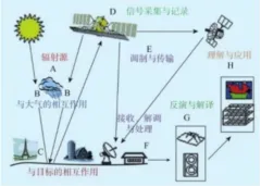
Figure: Basic Principles of Remote Sensing Satellites
Passive type: Perceives the electromagnetic wave characteristics emitted by detected objects through remote sensing sensors, including visible light, infrared, hyperspectral, microwave radiometers, etc.
Active type: Emits electromagnetic waves to the surface of detected objects through remote sensing sensors, and then detects the scattered signals of the objects, such as synthetic aperture radar, microwave scatterometers, etc.
Among them, Synthetic Aperture Radar (SAR) belongs to active remote sensing, which emits electromagnetic waves through space-borne radar remote sensing platforms and analyzes the backscatter echo signals obtained from ground objects. Although SAR satellite technology matured relatively late, it has the characteristics of all-time, all-weather operation, long-distance imaging, and strong surface penetration capability. Its ability to penetrate clouds, rain and the ground makes up for the defects of optical and infrared remote sensing.
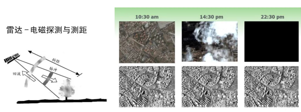
Figure: SAR Imaging Principle, Comparison between SAR Images and Optical Images
02 Industry Development Trends
From the supply side, China's SAR satellites are still in the early stage of development. Several SAR constellations or remote sensing constellations containing SAR satellites are under construction. However, limited by high launch costs, the current construction speed is relatively slower than that of foreign countries.
At the international level, developed countries in Europe and the United States took the lead in deploying SAR satellite constellations, effectively improving global coverage and rapid revisit capabilities. Among them, Finland's ICEYE is currently the largest SAR satellite operation company, having deployed 54 satellites as of June 2025.
The development of China's SAR satellites originated from national tasks and scientific research needs, with the main players being key institutional units such as the Fifth Academy of Aerospace Science and Technology Corporation, the Eighth Academy of Aerospace Science and Technology Corporation, and the Aerospace Information Research Institute. In 2006, China launched the major special project of the High-Resolution Earth Observation System (referred to as the "Gaofen Special Project"). As an important part of the Gaofen Special Project, SAR satellites entered a small-scale networking state after the successful launch of Gaofen-3 01 satellite in 2016. Based on other scientific research constellations, the number of SAR satellites in orbit operated by state-owned teams currently exceeds 20 (excluding military constellations).
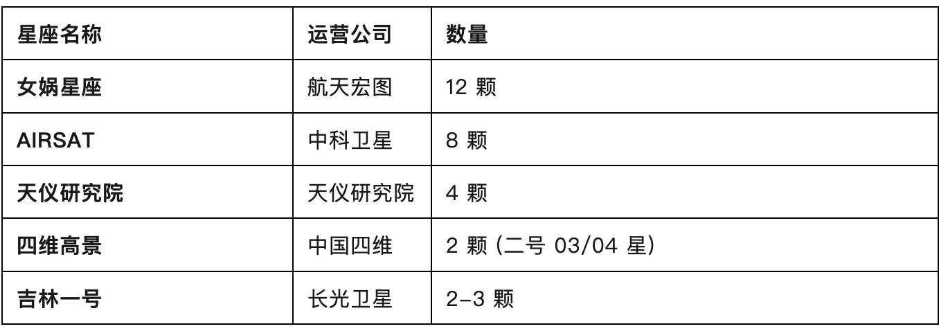
China's commercial SAR satellites have started to develop along with the progress of commercial aerospace since 2020, and have now entered a stage of rapid development. Relevant entities include commercial companies such as Micro-Nano Star, Zhongke Satellite, Spacety and Geo-iTech, as well as 4D GEO-Information Co., Ltd. affiliated to the Fifth Academy of Aerospace Science and Technology Corporation. At present, the number of various types of SAR satellites under application for construction exceeds 100.
Table: China's Commercial SAR Satellites in Orbit (Partial)
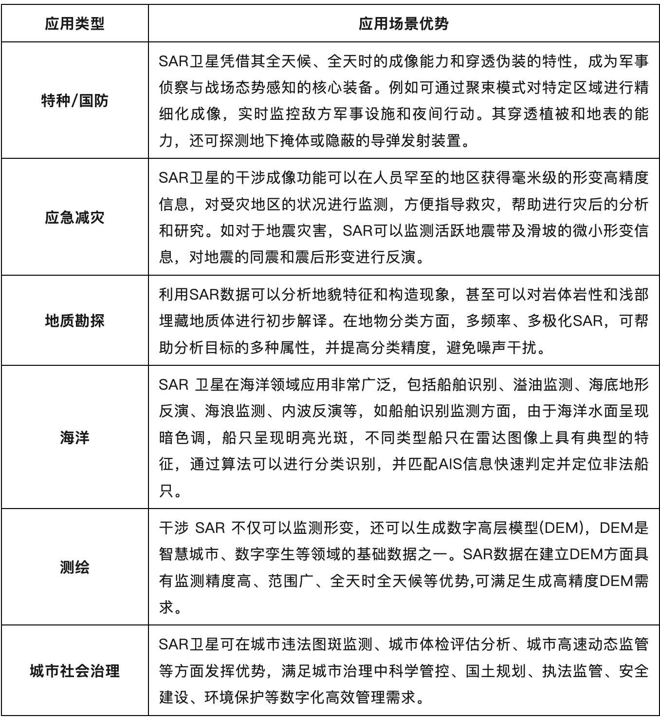
From the demand side, the application of SAR satellites has gradually moved from the early stage driven by national defense applications to a development stage of military-civilian integration and accelerated commercialization. The main application fields are shown in the following table:
Table: SAR Satellite Application Scenarios and Advantages
However, according to research, special applications of SAR satellites still account for more than 80% of the overall market, and civilian applications have not been carried out on a large scale. The main reasons include:
China has not yet achieved technological breakthroughs in the rocket sector. The high cost of constellation construction and operation has slowed down the progress of China's SAR constellation construction, making the data source difficult to meet user needs. At present, most enterprises engaged in SAR applications still mainly purchase foreign data.
High-performance SAR payloads come from research institutes such as the Aerospace Information Research Institute and the 38th Research Institute, but they are high-cost and supply-constrained. There are no private enterprises in China that supply cost-effective SAR payloads.
A sound industry application ecosystem has not yet been established. SAR image acquisition is costly and processing is difficult, and the payment capacity of downstream government (G-end) customers has been limited in recent years.
03 Thoughts on Investment Opportunities
Based on the above analysis, China's SAR satellite industry is still in the early stage of construction and application. Referring to the development history of optical remote sensing satellites, a number of commercial aerospace enterprises are expected to emerge in the constellation, application and payload sectors in the future, promoting rapid iteration of the industry. Therefore, we believe that the following directions can be focused on in the future:
Suppliers of low-cost, high-performance SAR payloads that have been verified in orbit;
Constellation operators with sufficient construction funds and independent SAR payload R&D capabilities or data application capabilities;
Application enterprises with strong control over data sources, excellent image processing algorithm capabilities and good market resources.
Source: Zhang Shijie, Investment Department VI
Reviewer: Xue Yao
Publisher: You Yi
